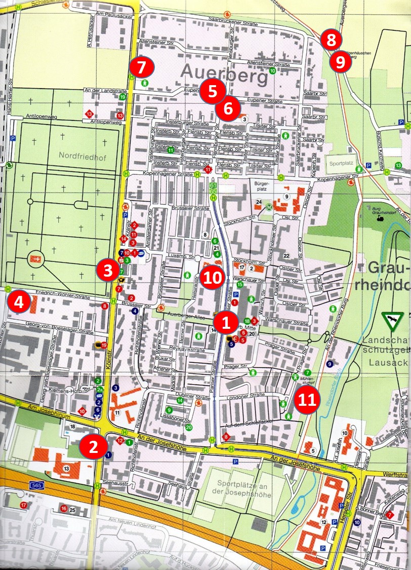
#1: Place at the centre of Auerberg
> Deutsch | > Türkçe | > العربية
Compared to neighbouring Bonn-Castell, Graurheindorf and Buschdorf, Auerberg has left behind its youthful teenager years only recently. Whilst plenty of centuries abound there, it's just 100 years here. Auerberg got its name in 1966, derived from historical field-names to the left and to the right of the Roman road to Cologne. This name apty plays with Auerberg‘s geographical location close to the river Rhine. Situated some 60 meters above sea level and about 15 meters above the normal river stage on its Older Lower Terraces, the settlements are not as exposed to occasional floodings as those on the Recent Lower Terraces are. The boundary to Graurheindorf follows first the Rheindorfer Bach (rivulet) and then the slope of the Older Lower Terrace until the mould of the Older Rhine (Auerbergweg). Originating in Buschdorf and heading to the ferry to Mondorf, Englaenderweg marks not only the northernmost boundary of Auerberg but also that of the Bundesstadt Bonn. Where the first German motorway to Cologne, the A555, opened in 1932, Auerberg borders the district of Tannenbusch. And in the south, Auerberg is contained by the motorway A565 from junction Bonn-Nord to the Nordbruecke (Friedrich-Ebert Bruecke, bridge), with Bonn-Nord and Bonn-Castell situated on the other side.
More than 10,000 inhabitants not only appreciate the traffic connections to the centre and to the adjacent cities in the region, but they also enjoy the charming environment as their recreational resorts. Auerberg is well equipped with a variety of private and public infrastructures. People from as many as 110 nations call this quarter their home. And the great number of children literally makes Auerberg a young quarter of Bonn.

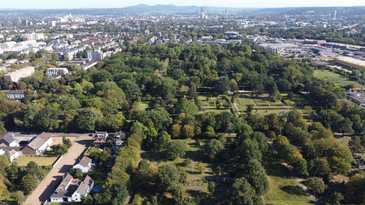
Flying from the centre of Bonn towards Cologne, you see the whole of Auerberg unfolding before your eyes. The motorway A565, heading towards the left side of the river Rhein (foreground), demarcates the quarter from Bonn-Nord and Bonn-Castell in the south, while the motorway from Bonn to Cologne does the same to Tannenbusch in the west. With its southern boundary running through the northern part of the Nordfriedhof, Buschdorf expands on the left of the straight road to Cologne, a relic of Roman times. The border of Bonn towards Bornheim-Hersel, which logically implies that of Auerberg, in the background goes through farmland and apple orchards along the Englaenderweg and heads to the ferry to Mondorf. The Rheindorfer Bach (the rivulet of Rheindorf) with its accompanying meadows as well as the Auerbergweg, edging past the Older Lower Terrace, both mark the border to Graurheindorf in the east. The conservation area "Rheinaue-Nord" guarantees the influx of fresh air for Bonn, thus making it a frequently visited greenbelt recreational area.
")
The extract from the map of Bonn illustrates how little the area and the extensive farmland were built-up in 1920. And yet, 100 years on, more than 10,000 inhabitants would find a home: in Bonn-Auerberg.
 Blatt 227")
Here you get a good view of Auerberg from the Kölnstraße and the Collegium Josephinum (a college) in the foreground to Graurheindorf and the river Rhine in the background. In the 1960ies the area was continually built up whereras the center of Auerberg would remain farmland until the early 2000ies. When the areal photo was taken, Auerberg had about 2,000 inhabitants, which changed dramatically within the years to come.

It took more than 25 years from scratching the first plans of Auerberg to their materializing in the late 1980ies. In 2015/16 the Auerberger Allee with its central place in Auerberg Mitte (centre) was completed. While stores for the daily needs are adequately provided for, other needs are found wanting. As for the central place there still is the desire of the public to find sufficient venues to socialize and to enjoy an attractive design of the place, created e.g by plants and seating arrangements. A so-called "Integrated concept for the development of Bonn-Auerberg", updated in 2018/19, is to show ways to remove the existing deficiencies. Beyond that, the idea of a green axis - from the Nordfriedhof (cemetry) via the Auerberg Allee and the Lausacker to the Rhine - lends itself to linking the centre to the green Rheinaue-Nord, which again would be upgraded by more plantings and alleys. Just a dream of the future?
text by Jürgen Haffke 2022
Literature and Sources
- Stadtarchiv und Stadthistorische Bibliothek Bonn (archive of the city of Bonn and its local history library)
- Franz Grünkorn, Jürgen Haffke, Florian Becker, Michael Dietrich: Bonns Nordwesten. Stationen der Entwicklung von Auerberg, Buschdorf, Graurheindorf und Tannenbusch. Bonn 1988, 2. Aufl. 1989
- Renate Schoene, Karl Wilhelm Starcke, Ruthild Stein (editors): Bonn-Auerberg. gestern – heute – morgen. Mit Beiträgen von Auerberger Bürgerinnen und Bürgern. Bonn-Auerberg 1992 (Bonn-Auerberg. Past – Present – Future. With contributions by authors from Auerberg)
- Plan-lokal GbR (Marco Eissing, Alfred Körbel, Martin Radke, Hanna Speidel): Integriertes Entwicklungskonzept (IEK) für Bonn-Auerberg. Im Auftrag der Bundesstadt Bonn, Stadtplanungsamt und Amt für Soziales und Wohnen. Dortmund May 2018, updated in 2019 (Integrated concept for the development of Bonn-Auerberg, commissioned by the City of Bonn)
- Dat Blättche. Nachrichten aus Auerberg und Graurheindorf. Hrsg.: Ortsausschüsse Auerberg und Graurheindorf. Bonn 1995 ff (News from Auerberg and Graurheindorf. Edited by the Local Association of Auerberg) (for further information consult: https://www.bonn-auerberg.de/ortsteilzeitung-dat-blaettche/ausgaben)
#2 Convent Church – The Earliest Settlement in Auerberg
Kölnstraße 415
> Deutsch | > Türkçe | > العربية
You meet a sculpture in an alcove in the outer wall of the convent church; it figures Saint Lazarus, the patron of the lepers. In our days this is the only hint at the infirmary in Bonn ("Leprosenhaus auf den Höhen"), which had been located at this place since the late Middle Ages (first mentioning in 1345). Far beyond the city walls, the persons ill with leprosy or other epidemics were cared for in numerous ooms, small and cellar-like, until the early 18th century. Ill 2.1 shows the Lazarus chapel at the beginning of the 17th century, which presumably replaced another building. Next to it was located the unpretentious "Hoeheguetchen" until 1868. These were the first buildings in today's Auerberg area. Opposite the entrance to the convent church, you can find a plaque commemorating the geographical survey of the Rhineland in 1847, in short: the "Bonner Basis".
In 1868 the socially committed Catholic Club of Bonn bought the entire estate of the "Hoeheguetchen", including the chapel. Their aim was to establish the scholastic and educational institute "Sankt Josef an der Hoehe". Its purpose was to "provide poor and left behind boys of Catholic belief with a sound education in religous and ethical affairs and with the indispensible teaching of skills that would be essential for their later lives and that would make them, with the mercy of the Lord, good Christians and citizens." In 1872 the institute put up its operation and in the subsequent years it considerably added more buildings for housing, teaching and working (Ill 2.2). At the location of the Lazarus chapel the neogothic church "Sankt Josef auf der Hoehe" was erected between 1883 and 1887, which now enjoys the status of a listed building, just as the adjacent buildings do. The architect was Heinrich Wiethase (1833-1893) who also designed the Stiftskirche. Since 1884 it developed as a favourite stop on the itinery from the city to the new cemetry.
Due to problems related to their personel and to their economic situation the Catholic Club sold the big estate to the Order of the Redemptorists, which had been founded in 1732. The struggle between the Prussian state and the Catholic Church had made them run their school "Collegium Josephinum" in Vaals, close to Aachen in the Netherlands. It was designated to raise the scholars of their order. It was pure coincidence that the local patron was named after Joseph as well. The steadily growing population of the region flocked to this convent church to become an important spiritual centre in their lives. The Fathers of the convent themselves did likewise and played their parts in the lives of the neighouring parishes. It did not take long that the boys living in the boading school of the order (the "Juvenists") came more from the entire Reich than from Bonn itself. From January 1940 to March 1945 the National Socialists closed the school, temporarily ran a military hospital, an institution for the training of teachers, and eventually provided a quarter for the police and for the forces responsible for the air raid protection. In December 1944 a mine not only immensely damaged the school building but also caused 14 fatalities. With the American occupation on 8th March 1945 the Redemptorists again moved in and relaunched school life. When Bonn was declared to be the provisional capital of the Federal Republic places in the communal Gymnasiums (similar to secondary schools) became so rare that in 1950 the city administration asked the Collegium Josephinum to open up to boys whose career was not necessarily devoted to becoming a priest or to joining the order. In the subsequent decades, the numbers of the pupils rose from 200 in 1950 to 800 in 1980. Yet, in the same period the number of the "Juvenists" dropped so much that the boarding school was eventually closed in 1983. Now, there are just three boys-only Gymnasiums in the whole of Germany (in Regensburg, Mainz and Bonn); and as for the Realschule there are not any, except for the one in Ehingen (in Baden-Württemberg) and the one run by the Collegium Josephinum in Bonn (Northrhine Westphalia). A shameful chapter of the school’s history dates back to the 1950s and 1960s, but had not surfaced before 2010. It challenges the fact that in the Collegium Josephinum some Fathers sexually mistreated several boys as their carers. Acknowleging the profound psychological injuries inflicted to the boys the order tries to honour their responsibilities. Both the Gymnasium and the Realschule have been well sought-after in Bonn and the region to the left and to the right of the Rhine.
Yet more additions and refurbishments of the old buildings had to be undertaken after the Realschule had been opened in 1976 and the Gymnsium had been built anew in 1980 (Ill 2.3). The convent church was renovated comprehensively from 1981 to 1983, the old school building was torn down in 1983, while in 1986 a new youth centre was designated and new lodging appartments offered to the Fathers. The old convent building was in part redesigned for assisted accommodations, furthermore the care home for seniors "Josefshoehe" was built in 2004 where the historic studios used to be (Ill. 2.4).
, Chapel of Lazarus, about 1840. Source: Stadtarchiv und Stadthistorische Bibliothek Bonn")
Nicolaus Christian Hohe handed down the image of the Lazarus chapel in Koelnstrasse, looking to Bonn. (In the background you can see the minster and the windmill on the city wall.) Source: Stadtarchiv und Stadthistorische Bibliothek Bonn

Put up in the convent is the big painting of the "scholastic and educational institute St Joseph an der Hoehe", which aptly illustrates the buildings in 1902 and the pastoral life in Koelnstrasse.

It was for just a few years only that the old and the new buildings of the Collegium Josephinum were neighbouring each other. Aerial view 2nd September 1980, Ernst Friedrich Seydel.

The school building, the convent church, the convent and the care home form a considerable complex at the entrance to Auerberg (Ill 2.4).
text by Jürgen Haffke 2022
Sources:
- Josef Dietz: Das Siechenhaus auf der Höhe. In: Heimatblätter für die Stadt Bonn. Beilage der Kölnischen Rundschau, Nr.11, November 1948, S.41–43 (The sick people’s home "Auf der Hoehe", complementary to the Koelnische Rundschau from 11th November 1948)
- Die Bonner Basis von 1847 als technik-geschichtliches Denkmal. Eine Dokumentation des Landesvermessungsamtes Nordrhein-Westfalen. Bonn-Bad Godesberg 1981 (The Bonn Basis from 1847 as a technological monument. A documentation by the office of land surveys Northrhine Westphalia)
- P. Peter Niesemann, W. Zachert, Th. Nießen, Walter Dorn: St. Joseph auf der Höhe. Klosterkirche der Redemptoristen. Faltblatt. Bonn 1983 (St. Joseph auf der Hoehe. A convent church of the Redemptorists. Leaflet)
- Wittkugel, F.: Die Unterrichts- und Erziehungsanstalt St. Joseph a.d. Höhe in Bonn. Ein Beitrag zur Jugendfürsorge. 2. Aufl., Bonn 1910 (The institution for childcare and education St Joseph an der Hoehe.)
- Collegium Josephinum (Hrsg.), Jürgen Haffke (Red.): 125 Jahre Collegium Josephinum Bonn 1880–2005. Bonn 2005
- P. Peter Niesemann: 100 Jahre Redemptoristenkloster Bonn 1920-2020. In: Collegium Josephinum, Jahrbuch 2019/20, Bonn 2019, S.33–45
- Jürgen Haffke, Ulrich Lipperheide, Dirk Berger: 100 Jahre Collegium Josephinum in der Schullandschaft Bonns und seines Umlands 1920-2020. In: Collegium Josephinum, Jahrbuch 2029/20, Bonn 2019, S.46–61 (100 years o fhe Collegium Josephinum in the educational regions of Bonn and its hinterland)
#3: Northern Cemetery
Kölnstraße 487
> Deutsch | > Türkçe | > العربية
All traces of the knacker's yard in the southern part of the "Nordfriedhof" (Northern cemetery) have been lost. Since the High Middle Ages this was the place where, century after century, those executed or the carcasses of animals were disposed of, and it was the place of the Bonn gallows - for the population to be deterred. The year 1777 witnessed the last executions. And yet, the old names of some streets tell us something about this historical chapter. The "Gerichtsweg", the "way to the court", is testimony of the High Court, as does the "Galgenpfad", the path to the gallows (Ill 3.1).
In the Middle Ages and the Early Modern Ages the deceased were mostly buried in the cemetries within the city. But in 1715 Elector (Kurfürst) Joseph Clemens had the "New cemetery" established beyond the city walls. Although this one was extended several times it reached its full capacity as early as 1884, due to the rapid growth of Bonn in the 19th century. It just became the "Old cemetery". In the same year, another cemetery with 15,000 burial places could be dedicated far beyond the city limits in Koelnstraße, on an area as big as 8 hectars. It was designed like a park (Ill 3.2). Its old trees and its pompous burial memorials leave behind impressions of those bygone times. It did not take long, before the size of the area doubled in 1900. It was renamed as "Northern cemetery", when in 1910 the "Southern cemetery" (Südfriedhof) was opened in Dottendorf. In 1913/14 the chapel and the momentous entrance gate at Koelnstrasse were erected with the inscription "Resurrecturis" (To those who will resurrect). Its massive body earned it its nickname as the "Egyptian Portal" (Ill 3.3). As parking lots were planned in 1962 the portal was demolished. These plans however never materialized, and neither did another attempt to restore it on the remaining pillars.
When the regional railway line from Bonn to Cologne along the Rhine, the so-called Bonn-Koelner Rheinuferbahn, started their operation in 1906 it ran direct behind the Nordfriedhof with an extra stop "Bonn-Nord", which made it much easier for the people coming from Bonn to access the cemetery. Later the line was redirected towards Tannenbusch. The stop was a prerequesite for the nearby metal works. World War I (1914-1918) urged the city to have a cemetery to honour not only its civilian vicitims but also those soldiers who died in the military hospitals, the prisoners of war, and the relatives of the occupying forces later on. It was not designed before 1933. The surrounding area was predominantly farm land and as such it was sparsely populated. Between 1933 and 1939 about 1,000 persons moved to the "Nordrandsiedlung" and to the houses in Richthofenstrasse.
Four years after WW II, the honorary cemetery was overhauled and redesigned in 1966 to commemorate some 2,000 casualties: the victims of the air raids, the soldiers, the prisoners of war, the forced labourers. In the year 1980 the Memorial for the Victims of the Wars and of the tyrannies was moved here from the Hofgarten in the city. It was here that the wreath-laying ceremonies accompanying the protocol of state visits took place. After the German reunification the Neue Wache in Berlin took over. Plans to build a crematorium on the Nordfriedhof came to nothing neither in 1981 nor in 2000. It became a listed place in 1984 und it was enlarged again, covering 25 hectars this time. Today the Nordfriedhof, the biggest cemetery in Bonn, is part of Auerberg with its 10,000 inhabitants. With its array of fine trees and its well looked-after design the cemetery is the only outstanding forest park in the region as regards to plant and animal life (Ill 3.4). It carries many associations, not only of the history of Bonn. Over a timespan of nearly 140 years, various nationals and members of different faiths have been buried here, partly in their designated sections (since 1987 for Muslims, since 2017 for the Chinese). Meanwhile many burial memorials have been taken down, while more and more urns take their places. Since 1988 there has been a section for the anonymous dead and since 2006 there have been collective graves for urns. In the publication for the 100th anniversary of the Nordfriedhof you can read in 1984: "Cemetries are open history books." How true is that!

Old names of ways and parcels in Auerberg. Source: Ruthild Stein 1992, after Karl Hoch 1949.

The map from 1893 shows how the Northern Cemetry was designed like a park, in the midst of an agricultural setting with few settlements. Source: topographic map 1:25,000 "New Survey", No 5208, edited 1895, Ordnance.

The momentous arch of the 1913 entrance gate to the Northern Cemetry was demolished in 1962. Parking lots had been planned, but were not built. In the end, the pillars are remaining testimonies of that planning. Photo: City archive and municipal historic library of Bonn.
The aerial photo dated from 25th September 2021 illustrates how the Northern Cemetry has been encircled more and more by the densely populated ares of Auerberg and of the city of Bonn. Photo: Jürgen Haffke.
Text by Jürgen Haffke 2022
Sources:
- Hansjörg Hunkler, Franz Grünkorn: Resurrecturis. Denen, die auferstehen werden. 1884–1984 Einhundert Jahre Nordfriedhof Bonn. Hrsg. Stadt Bonn, Garten-- und Friedhofsamt. Bonn 1984
("To those who will resurrect, 1884-1984, 100 years oft he Northern cemetery)
#4: 100 Jahre Aluminium in Bonn-Auerberg 1921–2021
Friedrich-Wöhler-Straße 2
> Deutsch | > Türkçe | > العربية
Most inhabitants of Auerberg would not notice the big industrial area off their habitual routes. It extends along Friedrich-Wöhler-Strasse, between the back of the Northern Cemetry and the motorway to Cologne (A 555). Since 1918, in its initial stage, metal was processed here in an iron rolling mill ("Bonn Eisenindustrie Ltd"), which however was closed in the same year, shortly before the end of World War I (Ill 4.1).
On 15th June 1921, the Erftwerk Ltd in Grevenbroich bought all shares of the disused works. This company became a 100 percent subsidiary of the Vereinigte Aluminiumwerke ("United Aluminium Works, VAW). They started off under the name "Eisen- und Metallindustrie Ltd" (Iron and metal industry ltd), running an aluminium rolling mill with 60 employees. In 1926 the factory was extended to now roll alloys as well ("Aluminium-Legierung Lautal Ltd), extending the staff to 200.
Its name then was "Lautal Walzwerk Ltd", but was changed into "Vereinigte Leichtmetall-Werke Ltd (Light Metall Works) just one year later, this time coining the company's image in Bonn up until now. This location was profiting from the regional railway between Bonn and Cologne (the Rheinuferbahn) that offered a junction, which was in use until 2007. From 1917 to 1968 they could even call an extra stop ("Bonn-Nord") their own. With the use of first an extrusion press from 1929 on, then of more presses, the production of rods, pipes and profiles from aluminium and its alloys became possible. More and more sheet rollings were deployed and the development of extremely hard ("hochfest") alloys ("Bondur" and "Albondur") in their own enterprise proved very successful from 1932 on. Basically, the company was geared up to play their part in the aviation industry, offering jobs to about 1,300 employees before WW II. The plant was spared from the air raids of the allied forces although those had classified it as relevant for the German warfare (spare parts, components and fuses of bombs). From 1941 on, countless labourers were forced to work there to uphold the production, the majority deported from Ukrania; they were held prisoners in a camp in Dellweg near Koelnstrasse.
At the end of WW II, the plant was confronted with its dismantling and with a temporary production ban. However, the location soon enjoyed an upgrade when the central administration of the VAW was transfered from Berlin to Bonn into the vicinity of the alloy works (25, Georg-von-Boeselager Strasse). After the company had encouraged housing projects in the late 1930ies in the Nordrandsiedlung in Saarbruecker Strasse (Ill 4.3), they again committed themselves to the housing sector, when the era of German reconstruction was passing by and when the company was expanding, employing about 1,800 workers in the 1960ies. The production was restructured internally, which led to a relocation of the rolling mill – and to a reduction of the staff: in the late 1980ies about 700 workers were busy in the production process.
Since 1964, the importance of aluminium for Bonn is underlined by a research institute next to the main VAW headquarter, focusing on alloys. In 2002 it was taken over by Hydro, which again was taken over by a New York-based hedgefond, on 1st June 2021. Since then the branch based in Bonn is now being called "Speira". The investor, Cube Real Estate, acquired a somehow bigger plot, on which they intend to establish an industrial park along some housing units.
In 2002 the entire VAW group, which had been part of the E.ON group, changed into the hands of Norsk Hydro, thus making the main administration in Bonn redundant. From 2015 to 2019, 200 refugees mainly from Syria temporarily found shelter in a part of the administration building. It should be mentioned that VAW had sold the alloy works to the Dutch Hoogovens Group back in 1996. Four years later, in 2000, they amalgamated with British Steel, which from then on was named "Corus Aluminium Profiltechnik Bonn Ltd". Six more years into the new millenium, in 2006, ownership changed hands again. This time its name was "Aleris Aluminium Bonn Ltd" (Ill 4.4). It took Aleris nine years before they sold their aluminium branch to the Japanese Sankyo Tateyama Inc.; they, again, possess "ST Extruded Products Germany" (STEP-G) with their plant located in Bonn, employing more than 300 members of staff. The company is a global leader in manufacturing extruded aluminium profiles. Currently VW has placed a big order to produce system components for electric cars, while ready-to-use components for the bodyworks of the high speed trains have already been delivered for years. In 2014, DHL aquired a part of their site to establish a logistics centre, where 12,000 parcels are distributed by 100 employees.

Extract from the city map 1920. The red circle marks the little iron rolling works and the stop ‚"Bonn-Nord" of the regional railway. Source: City archive and municipal historic library of Bonn.

The station "Bonn-Nord" – Auerberg's junction to the Rheinuferbahn. Source: Collection by Jean Riemann, Wesseling.

The "United Alloy Works" in 1959, with thinly populated Auerberg, but without the motorway 565 and the Friedrich-Ebert Bridge, which have changed the scenery since 1966, cutting through the area. Source: Hamburger Aero-Lloyd, City archive and municipal historic library of Bonn.

The aereal from 31st August 2011 shows the company's area, which at that time belonged to Aleris, but was sold to STEP-G in 2015. In 2014, DHL converted the greenland with trees on the left of the industrial buildings into a logistical hub. The first phase oft he new centre of Auerberg has been completed and already hosts grocery stores. Source: Archive of STEP.
Text by Jürgen Haffke and Horst Peters 2021
Sources:
- VAW Leichtmetal GmbH, 50 Jahre für das Aluminium. Bonn 1977 (United Alloy Works.Ltd, 50 years for alloys
- Horst Peters: Hundert Jahre VAW-Aluminium Technologie. 2021 (100 years of VAW alloy technologies)
#5: The Nordrandsiedlung
Round about at Flensburger Str. / Eupener Str.
> Deutsch | > Türkçe | > العربية
After WW I, whilst the inflation made the contributions of the better-off people to the tax revenues of the city dwindle, the administration of Bonn intended to balance this with immense locations of businesses. Large areas were set aside for this purpose between Koelnstrasse, the Rhine and the northern limits of the city. Key to this project should have been the "Werftbahn", a railway line that had connected the Rheinuferbahn with the new port in Graurheindorf since 1924. Four branch lines should have helped develop the entire area, which extended from Obersten Hoehweg (now "An der Josefshöhe") to Englaenderweg (Ill 5.1). The economic problems of the Weimar Republic however frustrated the implementation of this industrial area. And yet, the track of the "Werftbahn" turned out to be decisive: it defined the northern limit of Bonn's settlement.
"At the fringes of the big cities settlements and allotment garden colonies should be established for unemployed people," the Rheinische Zeitung detailed on 10th November 1931. Even though the Homestead Act of the Weimar Republic had supported the building of settlements for unemployed craftsmen since 1920, it did not materialize in Bonn before 1931. In 1932 and 1933, all in all 40 homesteads were erected in the DIY way, the first ones in Tannenbusch (Berta Lungstras-Strasse) and at the Mondorfer Bach (Mondorfer Strasse) (Ill 5.2, red circle 1 and 2). Those who had been keen on banding together as individuals did so in the settling community of Bonn-Nord. From 1933 on, they were obliged to become members of the "German Settlers‘ League", the Nazis decreed. In the same year, construction of the "Nordrandsiedlung", as it was called, started (Ill 5.2, red circle 3). Until 1938, 71 semi detatched units were being erected with the development of electricity and water supply lines and of the roads going hand in hand. But the sewage lines were missing. In fact, from the start up until 1934, those involved were the unemployed artisans without financial resources, but with many children. Between Koelnstrasse and Flensburger Strasse and along Eupener and Allensteiner Strasse they built two types of houses, depending on the famliy size. The settlers did so semi-autonomously. Most of the houses did not have cellars in full scale and the communal plots were leased as hereditary tenancies. They were 800 to 1,200 sqm large (Ill 5.3). In the second phase from 1934 onwards the houses beyond Eupener and Allensteiner Strasse, opposite Flensburger Strasse, were added. These settlers, in contrast, could call some of the resources their own. The houses along Saarbrücker Strasse were the last ones to be built. Their tenants worked predominantly in the light metal works and enjoyed the support of their employers. Sheds for small animals were attatched to all houses and the gardens should help the people become self-sufficient (Ill 5.4).
In 1936/37 another housing project with 35 units was managed in Richthofenstrasse by the "Bonner Wohnungsbaugenossenschaft", a housing cooperative (Ill 5.2., red circle No 4). Before World War II this "early Auerberg" totalled 1,000 inhabitants. In the winter of 1940/41, a subterranean water tank to extinguish fires was built near Eupener Strasse and Flensburger Strasse. And indeed: the local railway to the port, the port itself, the light metal works, the ferry to Mondorf and the anti-aircraft deployments at Englaenderweg were potential targets of air raids. In 1943/44 three air-raid shelters were added at a depth of 14m with a connection of Koelner and Eupener Strasse on theone side and Allensteiner Strasse on the other side. Although they had not been completed, they did offer the population shelter. What has remained until today are the massively armoured access points next to the Schuetzenhaus at 584, Koelnstrasse, and at the "Buscher Plaetzchen" at 17, Allensteiner Strasse. In gratitude for surviving the war without major devastations, citizens of the north of Bonn and of the Nordrandsiedlung inaugurated the "Heiligenhaeuschen" in 1953.
They had been motivated to do so by Father Michael Kremers, then the Catholic priest in the parish of Sankt Josefs-Hoehe. In the post-war years and in the years of the "German economic miracle", the strong solidarity of the Settlement Community of Bonn-Nord proved helpful in many ways: they organized tools and materials for landscape gardening, they cooperated with the setting up of the sewage system in 1965 or they assisted the population in legal matters. What is more, social clubs, just to name the "Männerreih (?) Gemütlichkeit" (1948), the "Sonnige Siedlerinnen" (literally "the Sunny Settlement Ladies")(1949), and the "Sebastianus Schuetzenbruderschaft" (1950), were livening up the festivities and parties in the decades to come. In those days the area was expanding heavily towards the city of Bonn, but had not officially been named "Auerberg" before 1966. Three steps strengthened the development of a social centre: the inauguration of the Bernhard Church in 1956, the relocation of the kindergarden St Theresa from the "Auerberghaus", which became the home of the Schuetzen in 1984, to the new kindergarden and the opening of the vicarage in 1974. In the years between 1976 and 1978 many settlers of the Nordrandsiedlung accepted the offer of the city administration to convert their leases into property. Nowadays you can hardly find a house in its original state but with additions and conversion, with decorative gardenings instead of gardens proper (Ill 5.5). "The settlers" cherish their traditional community and they nurture their pride to have created a respectable setting in Bonn, having started up from the modest circumstances, which in those years were marked by suffering and privation (Ill 5.6).

In 1924, the new port of Bonn (the "Rheinwerft") was inaugurated in Graurheindorf. The "Werftbahn" not only established a connection to the regional Rheinuferbahn, but it should also have helped develop a big "industrial area". However, this was to become the location where Auerberg has developed since 1933 in several steps. Source: City archive and municipal historic library of Bonn.

After the convent, the Northern Cemetery and the metal works (blue triangles) were sparsely spotted in the area, the settlement projects in the marginal areas of the city (Stadtrandsiedlungen, red cicles 1 – 3) were meant to be the crucial steps for the development of Tannenbusch and Auerberg. The map from 1938 documents how isolated the settlements were in relationship to the city centre. Source: Map of the Nordrandsiedlung, dating from 1938, edited in 1947.

Autumn 1933: Settlers in front of a pical house. Each unit housed two homesteads (left and right halves), with sheds to keep small animals. Source: Archive of the settlers' community Bonn-Nord, Gottfried Metzen.

The aereal photo from 19th September 1938 shows the recently completed settlement area with its garden lands, still void of trees. Source: Straehle Luftbild, city archive and municipal historic library of Bonn.
, photo: Jürgen Haffke")
The settlement of the old Nordrandsiedlung along Saarbrücker Strasse, Allensteiner and Eupener Strasse (photo from a drone taken on 25th September 2021) now poses as an attractive residential area with its pretty gardens and the landscape preserve Klosteracker/Rheinaue nearby. Photo by Jürgen Haffke.

The drone photo from 2nd July 2018 shows in the foreground the green Nordrandsiedlung with its many trees and refurbished houses and with the Bernhard Church in front of the densely populated centres of Auerberg and of the city of Bonn, whilst the Siebengebirge lends itself to a charming background. Photo: Jürgen Zens.
Text by Jürgen Haffke 2021
Sources:
- Heinrich Schmitz: Zum Jubiläum 1933–1973. 40 Jahre Siedlergemeinschaft Bonn-Nord in der Siedlervereinigung Bonn Stadt und Land. Bonn-Auerberg 1973 (40 years' jubilee of the settlers' community of Bonn and of Auerberg.)
- Hans Noltensmeyer: Zum Jubiläum 1933–1983. 50 Jahre Siedlergemeinschaft Bonn-Nord. Bonn-Auerberg 1983 (50 years' jubilee of the settlers' community of Bonn and of Auerberg.)
- Gottfried Metzen: Zum Jubiläum 1933–1993. 60 Jahre Siedlergemeinschaft Bonn-Nord. Bonn 1993 (60 years' jubilee of the settlers' community of Bonn and of Auerberg.)
- Gottfried Metzen, Ria Montag, Maria Thomas: Unsere Nordrandsiedlung, erbaut 1933–1936, heute Siedlergemeinschaft Bonn-Auerberg. 2013 bestehen wir 80 Jahre. Zeitgeschehen. Bonn-Auerberg 2013 (Our Nordrandsiedlung, built between 1933 and 1936, is has been our settlers' community for 80 years.)
- 85 Jahre Siedlergemeinschaft Bonn-Auerberg 1933–2018
#6: Catholic Church St. Bernhard
Eupener Str. 26
> Deutsch | > Türkçe | > العربية
From today's point of view, the location of the Catholic church "St Bernhard", somehow marginal within the parish of Auerberg, raises questions. When it was built in 1955/56 the area stretching towards the city of Bonn was nothing but farmland. So, the location of the church followed the "Nordrandsiedlung" from the 1930s (Ill 6.1). In a short timespan, more than 1,000 people had moved here and to Richthofenstrasse, among them many Catholics. They expected religious guidance form the Parish of Graurheindorf with its Margaretenkirche and the convent church St Josef an der Hoehe in Koelnstraße. As for the space and the staff needed for this role, neither of the two churches could meet the expectations in any way. The Pastor of Graurheindorf should be supported: upon the proposal of the local dean, Father Michael Kremer from the Redemptorists took over the duties of the "Pastoral district of St. Josephs Hoehe", including the Nordrandsiedlung and Tannenbusch, which at that time did not have a church of their own. In 1943, Father Kremer organized a "makeshift church" in his flat in the privately owned house of Family Reuter (399, Koelnstraße), while the convent church was being shut down by the Nazis in the years 1941 to 1945.
As modest venues for the people to meet and contemplate their religion, the Lourdes Grotto was built in 1949 south of the light metal works and so was the Heiligenhaeuschen (Little Holy Hut) four years later, in 1953, near the Nordrandsiedlung. In the spring of 1951, the episcopal vicarage in Cologne acknowledged the urgency to build a new church for the Nordrandsiedlung. The acquisition of a suitable site, however, was dragging on for another three years. The Bonn architects Toni Kleefisch and Carl Leyers designed the plans, so the building of the church and the adjacent Parish could start on 27th June 1955, the foundation stone was laid on 21st August and the topping-out ceremony took place on 19th November in the same year. This process was unfolding, while Father Paul Kerzmann was in office. Before the new church was completed on 23rd December 1956, the fourth advent of that year, a "Kirchbauverein", a charity to accompany the development, had been committed to furnishing the new church. The Auxiliary Bishop Josef Ferche conducted the consecration ceremony, establishing at the same time a new parish in its own right. Nominating the church and the parish "St Bernhard" should appreciate its link to the parish in Graurheindorf, which, historically speaking, stems from the monastry of the Cisterians ("Grey Sisters"). This order had venerated Saint Bernard of Clairvaux.
From late 1955 to 1961, Josef Schaefer served as the pastor of St Bernard. Thanks to his commitment, the artist Paul Magar (1909 – 2000) created the inspiring and precious mural behind the altar. When he encountered a fresco of that artist in a church in Pronsfeld (Eifel), the pastor fervently wished something similar for St. Bernhard; he wanted his favourite song "Wachet auf, ruft uns die Stimme") (composed by Philipp Nicolai in 1599) to be graphically transposed. It took the artist the short time-span from autumn 1961 to Christmas of the same year to finish his great oevre. The space around the altar underwent reconstructions in 1986 and in 2011, 50 years after the fresco had been installed. On that occasion the view on that piece of art from the church goers' perspective was unblocked. What is more, the charm of the fresco was doubled when in 2020 the benches of the church were removed, due to the Covid pandemic.
Paul Magar created an aluminium relief, entitled "Ite missa est". It translates as "You may part, the service is over" and alludes to the ceremonial words "Depart in peace". He made offered this remarkable work of art to the church, because the congregation of St Berhard had donated it to their pastor, Father Matthias Harren (1968 – 1986), to mark his Silver Jubilee in 1977. Using layered aluminium plates to design the motifs expresses the close relationship to the VAW light metal works and to the quarter, which is home to many people and the work place of many employees. This way, the fresco of the altar along with the aluminium relief by Magar are part and parcel of an impressive ensemble that attracts the visitors' eyes upon their arrrival, their remaining and their leaving the church.
Since the 1960ies, the development of Bonn as the capital city of the Federal Republic of Germany is reflected in the massive build-up of the new quarter, which was called "Auerberg" in 1966 (Ill 6.4). A new Kindergarden (1966, extended in 2013, Ill 6.4) and a parish house (1974) close to the church complemented the institutions of St Bernhard, which was sovereign until 2002. A shortage of clergymen in the Cologne diocese as early as the late 1980ies made a reorganization of the parishes in Bonn necessary. There were districts in close range and "pastoral districts". From 10th September 2002, the parishes of St Aegidius (Buschdorf), St. Bernhard (Auerberg), St Hedwig (Bonn-North), and St Margareta (Graurheindorf) constituted a pastoral community, which later, on 1st January 2010, merged into the parish union "Im Bonner Nordwesten" ("in the North West of Bonn") together with neighbouring St Antonius (Dransdorf), St. Laurentius (Lessenich), St Paulus (Old Tannenbusch) and St Thomas Morus (New Tannenbusch). Three years later, this union evolved to form the pastoral community of "St Thomas Morus", encompassing eight churches, with St Bernhard in Auerberg being one of them.

Up until the late 1950ies the view from Koelnstrasse across the farmland on Bernhard church was unblocked. Photo from the collection of Karl Hoch 1960. Source: City archive and municipal historic library of Bonn.

"Wachet auf, ruft uns die Stimme." The grand fresco of Paul Magar has dominated the interior of St Bernhard since Christmas 2020. Photo Hans Werner Schallenberg 2020.

"Ite missa est." Paul Magar created the aluminium relief in 1977; it wishes farewell to the church goers. The material embodies the close relationship with the local aluminium works, which has existed in Auerberg since 1921. Photo: Juergen Haffke 2021.

The view covers the area from Graurheindorf to Koelnstrasse / Northern cemetry. Since the 1960ies, the farmland has been gradually converted into housing areas. The "Nordrandsiedlung" around St Bernhard has been incorporated into "Auerberg" within a few years. Source: Aero-Lux 29/06/1963, Stadtplanungsamt Bonn, Blatt 225.
Text by Jürgen Haffke 2022
Sources:
- Chronik des Seelsorgebezirks St. Josefs-Höhe Bonn. Vom 1. Febr. 1938 – 31.Dez. 1956. Pfarrarchiv Bonn, St. Thomas Morus, Bestand Auerberg, St. Bernhard, Sig. 138 (Chronicles of the parish of St Josephs-Hoehe Bonn, from 1st February 1938 to 31st December 1956. Archive of the parish Bonn, St Thomas Morus, part Aurberg)
- Katholische Pfarrgemeinde Bonn-Auerberg (Hrsg.), Jürgen Haffke (Red.): St. Bernhard in Bonn-Auerberg. 25 Jahre. Bonn-Auerberg 1981 (25 years of St Bernhard in Bonn-Auerberg. Published by the Catholic Parish of Bonn-Auerberg, edited by Juergen Haffke)
- Pfarrgemeinderat St. Bernhard (Hrsg.), Ingeborg Höver, Josef Langer, Martina Wurm-Ditttkrist (Red.): 40 Jahre Pfarre St. Bernhard. Pfarrbrief Nr.2/1996
- Katholische Pfarrgemeinde St. Bernhard, Bonn-Auerberg (publisher), Holger Friedrich (editor.): 50 Jahre Pfarrgemeinde St. Bernhard Bonn-Auerberg 1956–2006. Bonn-Auerberg 2006 (50 years of the Parish of St Bernhard Bonn Auerberg 1956 – 2996)
- Kirchengemeindeverband "Im Bonner Nordwesten", Pfarrer Hermann Bartsch (publisher): "Wachet auf". Das Altarfresko des Bonner Künstlers Paul Magar. Bonn 2011 ("Wachet auf!", the fresco by the Bonn artist Paul Magar)
- Josef Herberg (Hrsg.): Kirchen in Bonn. Geschichte und Kunst der katholischen Pfarreien und Gotteshäuser. Petersberg 2011
#7: Traces of WW II in Auerberg 1939–1945
Kölnstr. 584
> Deutsch | > Türkçe | > العربية
There is not the faintest hint at the big container with its fire fighting water. It is still located below the street at the round about infront of Bernhard Church, and at the entry of Eupener Strasse. In late autumn 1940, two semicircular pipes were built. They measured 21 resp. 29 metres in length, were 3.2m by 3.8m wide inside and were equipped with two pumps. (Ill 7.1 and 7.2), 4m below the surface. They were meant to provide suffient water to extinguish fires caused by air raids. Luckily enough, they never had to be made use of; today the firebrigade of Graurheindorf services the facility.
Since the end of 1942, plans had been elaborated to build an air raid shelter, with the name "Siedlung Kölnstrasse", just as the Nordrandsiedlung was called. Fears were running high that the light metal works, which produced military items, were at risk of air raids, just as the Werftbahn to the harbour of Bonn was, which could cause lateral damages in the housing areas nearby. On March 10th, 1943, the building the project was launched. 14m deep under, three tributary tunnels, one from Kölnstrasse, from Eupener Strasse and from Allensteiner Strasse each, should be connected like a big T. The daily work force counted 30 men, among them up to 20 French prisoners of war. And yet, the site was never completed before the end of WW II. The tunnels, whose walls were 2.2m high, 2m wide and 20 to 50 cm thick (Ill 7.4), suffered from temporary ground water leakages and were lit only sparsely. But they did offer shelter, which, luckily, was never tested. The buildings on the ground, offering access to the facility, were armoured so heavily that tearing them down would have been too costly. In the end, these testimonies of WW II are still visible in today's building stock: at 584, Kölnstrasse (Ill. 7.6) more than at 17, Allensteiner Strasse, at the "Buscher Plätzche" (Ill 7.6), or at 10, Eupener Strasse (Ill 7.7). The buildings accessing the internal stairs, however, were sealed with concrete shortly after WW II.
There are several bottle banks on a concrete platform at the junction of Flensburger Strasse and Saarbrückener Strasse, embraced by railings. Inconspicuous as they are, these are the last remains of a "station" of an aerial cableway that was under construction since the end of 1944 to facilitate the transport of weapons and other material from the left bank of the Rhine to the right bank, in case the Mondorf Ferry should not operate. The construction was aligned parallel to the Werftbahn before it would cross the river and its flood plain on a few pilones. Only a few steps could be developed before the end of the war. After the occupation of the American forces in Bonn on March 8th, 1945, the Nordrandsiedlung did come under heavy fire from the direction of Mondorf. An American tank, deployed near the "station" of the cableway, answered back and flatted the church tower in Mondorf.
All in all, the Nordrandsiedlung survived the years of WW II without major losses. 44 men of the settlement lost their lives at various fronts, a man and a woman were killed in an air raid. In 1953 people from the settlement showed their gratitude by building the Heiligenhäuschen (Holy Hut). Close to Bernhard Church, the local community inaugurated in 2001 a cenotaph with the names of the victims of WW II.

The 21m and 29m long concrete tunnels, dating from 1940, have the size of a swimming pool. They are hidden under the street, recognizable by two manhole covers only. Source: City archive and municipal historic library of Bonn.

Both concrete tunnels are excavated in a 4m deep hole, they measure 3.2m in height and 3.8m in width. Source: City archive and municipal historic library of Bonn.

The original plan from 1942 was this: a tunnel should begin in Kölnstrasse, extend 14 m deep down to a gravel pit, which has been filled meanwhile, and in the end should join tunnels rectangularly from Allensteiner Strasse ("Buscher Plätzchen") and Eupener Strasse. Source: City archive and municipal historic library of Bonn.

The tunnels were 2.2m high and 2m wide only, which made them very cramped. Since the facility was deep down, ground water permeated every now and then. Source: City archive and municipal historic library of Bonn.

The massively armoured building accessing the internal stairs to the tunnel at 584, Kölnstrasse, next to the home of the associations of marksmen. Photo: Jürgen Haffke.

Completely overgrown with plants, the building accessing the tunnel at the "Buscher Plätzchen" is barely visible. Photo: Jürgen Haffke.

At the "Plaetzchen" in Eupener Strasse, just an inconspicuous concrete block reminds the people of the access to the tunnel. Photo: Juergen Haffke.

The concrete platform and the embracing railings behind the bottle bank have been left over from the "station" of the aerial cableway from the end of 1944. In the background the church tower of Mondorf can be seen. Photo: Juergen Haffke.
Text by Juergen Haffke, 2022
Literature and Sources:
- Juergen Haffke: Die Nordrandsiedlung im Zweiten Weltkrieg. In: Dat Blättche 2015, 3, S.15–20; 2016, 1, S.3/4 (The Nordrandsiedlung in WW II)
#8: Holy Chapel
Saarbrückener Straße
> Deutsch | > Türkçe | > العربية
How to conjure a place of contemplation in an area that was not only far beyond the city limits but also untouched by any religious and economic pivot - apart from some housing estates?
The pre-history
Father Michael Kremer, who was the pastor for the Nordrandsiedlung and for Tannenbusch from 1933 to 1938, had heeded the plan long before. He was keen to "add pietous colours to the grey and cool Nordrandsiedlung that lay at quite a distance from the church in Graurheindorf." These are the words the Father used in the "Chronicles of the Parish St. Josefs-Hoehe from 1938 to 1956", from which more quotations will follow. (archive of the parish of Bonn, St. Thomas Morus, part Auerberg). But that wish to realize was unthinkable in the times of the Nazis and of WW II. When he was convalescing in Lower Bavaria in 1947, he encountered a "Heiligenhaeuschen" (Holy Chapel). "It literally shielded the lingering visitors from their environment and lured them into the sacred space the next moment." Soon after, a wooden model was kept in his office for years.
The "Lourdes grotto", 1949
In 1949, Father Kremer got to know a "Lourdes grotto", when he was on a health spa in Camberg. "Could perhaps a similar grotto edify and console the faithful of St.Josefs-Hoehe as well as revive the veneration of Virgin Mary?" Within a couple of weeks locals and donators got active and built the Lourdes Grotto and inaugurated it on 8th December 1949. It was located on private land at the corner of Hoehweg and the way to the motorway bridge, opposite the light metal works where now the Maltese have their office. That way, the inhabitants of the Tannenbusch-Siedlung found an opportunity for a short prayer when heading to the service in "St Joseph an der Hoehe". But in the mid 1960ies, the extension of the motorway had the grotto torn down.
Building the "Heiligenhaeuschen" (Holy Chapel) in 1952/53
After the urgent building of the kindergarden St Theresia (now the house of the Schützen in 584, Koelnstrasse) was completed, Father Kremer could concentrate on the building of the "Heiligenhaeuschen". Initially, it should have been dedicated to the "Mother of Permanent Help", who was venerated above all by his order, the Redemptorists, in the convent at 415, Koelnstrasse. "However, when on 1stNovember 1950, Pope Pius XII announced the dogma of Virgin Mary's bodily transfer into heaven, the theme of Queen Mary was brought to the fore." A municipal piece of land between Buschdorfer Kirchweg and the Hafenbahn grants a glimpse from a little hill onto the flood plains of the rivers Rhine and Sieg with their villages of Graurheindorf and Mondorf. "That is the place for a little silent prayer, off the busy traffic nearby." Toni Kleefisch, the architect from Bonn who had already overseen the building of the Bernhard Church, provided for the plan for the Holy Chapel. Many local craftsmen from the Nordrandsiedlung, from Tannenbusch and from Bonn-Nord got involved into the project; it was eventually consecrated on 24th March 1953. What was missing, however, was an image of Queen Mary's coronation; for a start, it was replaced by an image of the "Mother of permanent help" from the local kindergarden.
The Votive Tablet
In the following, the chronicles of the parish of St Josefs-Hoehe say: "The one votive tablet of marble that Willi Moehle produced says what the people from the Nordrandsiedlung considered to be the initial motiv for building the Holy Chapel. It was their gratitude to God and His sacred Mother for protecting them in the last war (1939-1945). It was just at the very spot of the chapel that the only bombs were dropped right across the settlement, on Easter Monday 1942. Little damage was caused at the house of Family Neuhaus at 1, Danziger Strasse.
The inscriptions of the votive tablet read:
"TO THE LADY TRANSFERED INTO HEAVEN"
Pope Pius XII on 1st November 1950
THE SETTLEMENT OF BONN-NORD IN GRATITUDE FOR THEIR PROTECTION IN WW II (1939 – 1945)
25TH MARCH AD 1953
Now the faithful of the Nordrandsiedlung had a spiritual focus on their way to the service in the church St. Margareta in Graurheindorf (Ill 8.1).
Father Kremer wrote a letter to his superiors on 28th December 1953 to postpone his transfer. "Just to mention, I would like to see our Holy Chapel of Queen Mary being completed by a picture painted behind glass and by two stained glasses. Thanks to my commitment, the respectable chapel has been made up purely from donations of potent friends."
The picture "Queen Mary", 1954
The glass painter Felix Senger from Berlin-Dahlem was commissioned to not only paint the "Coronation of Mary" behind glass, but also two leaded pictures for the windows on the side, portraying angels. Due to a heavy work load, the picture with Mary was delivered one year later, in March 1954. But the two pictures that were offered for choosing were broken on their way to Bonn. "After four weeks a newly painted picture, this time on safety glass, was well packed to arrive safe and sound. It could be fitted into its niche at the end of May 1954. (Ill 8.2). The painter had been inspired by a mural painting from 1886/87 in the church St. Joseph an der Hoehe, which was the convent church of the Redemptorists since 1920 (Ill 8.3). The windows on the sides of the Holy Chapel with its angelic motifs were vandalised in the 1970ies and have been sealed with stones since then.
In WW II, Felix Senger got to know Father Wilhelm Lueckerath, a Redemptorist from Bonn. After his release from American captivity he spent some months in the Bonn convent and sketched stained glasses for all the broken windows there. "Unfortunately these sketches could not be realized at that time (in 1946), because the British military government had not licensed the necessary production of the antique glasses in the glass factory in Sindorf." Not before 14th May 1951 was one of his sketches fitted into the facade of the convent curch; it honored the victims of the war and carried the inscription: "He who sleeps, shalt wake up and be enlightened by Christ." This certainly was the occasion when Father Kremer and artist Senger encountered each other. More works by Felix Senger are drawings in a gallery in Berlin (1935), a painting of a lignite open cast mining with a power station in Milwaukee (USA) (1939), a window titled "The Birth of Christ" in the side ailse of the Liebfrauenkirche in Koblenz (1953), and a glass window in the city hall of Berlin-Zehlendorf (1955).
The Holy Chapel today: The landmark of Auerberg
The consecration of these churches paid tribute to the religious needs of a rapidly growing population in the northwest of Bonn: the Catholic St Paulus Church in Tannenbusch (1953), the Catholic Church St Bernhard in the Nordrandsiedlung (1956), the Protestant Church of the Apostles in Tannenbusch (1956), the Catholic St Hedwig Church in Bonn-Nordstadt (1962) and the Protestant Community Forum (1974). And yet: the Holy chapel has turned out to become the landmark of Auerberg. Since 1982, the annual ecomenical Gotteslob has been celebrated there. The local club carried a motion with the city council for the chapel to be listed as a monument, which was first rejected in 1986, but accepted four year later, in 1990.

The Lourdes Grotto was torn down in the mid 1980ies due to the extension of the motorway. It has been lost in near oblivion.

The Holy chapel, consecrated in 1953, offerd an unblocked view on the northern plain of the Rhine and on the Church of St. Margareta in Graurheindorf. Source: archive Jürgen Haffke.
, photo taken by Juergen Haffke in 2025")
In 1954, Berlin artist Felix Senger painted the picture "Queen Mary" behind a security glass pane. Photo taken by Juergen Haffke.

The inspiration for the painting in the Holy Chapel is the painting from about 1887 "The Coronation of Mary" in the church of St. Joseph an der Hoehe 415, Koelnstrasse. Photo taken by Hildegard Ameln-Haffke.
Text by Jürgen Haffke, 2022
Sources:
- Chronik des Seelsorgebezirks St. Josefs-Höhe Bonn. Vom 1. Febr. 1938 – 31.Dez. 1956. Pfarrarchiv Bonn, St. Thomas Morus, Bestand Auerberg, St. Bernhard, Sig. 138 (Chronicles of the parish of St. Joseph an der Hoehe from 1st February 1938 to 31 December 1956; Archive of the parish Bonn, St Morus, part Auerberg)
#9: The Landscape of the Bonn Region
Hafenbahn / Buschdorfer Kirchweg / Auerbergweg
> Deutsch | > Türkçe | > العربية
Where the Lower Mittelrhein with its steep slopes on either side and the Siebengebirge accompanying it overlaps into the Cologne-Bonn bay with its widening plains lies Bonn. This charming location is the scenery of our home. The view from the Auerberg "Heiligenhäuschen" (Holy Chapel) towards the Rhine reveals distinctive elements: the rolling plains with farmland, strips of bushes and trees, the church towers of Graurheindorf and Mondorf. But if you want to know more about the landscape, you are advised to walk from Mondorf Ferry to the former restaurant "Heimatblick" on the ridge of the "Ville". On your way there you will pass Buschdorf, Tannenbusch, Roisdorf, and Alfter. The region is shaped by several terraces (Ill. 8.1).
The excursion starts at the Mondorfer Fähre (ferry), where the Rhine shows a mean water level of 45 m NN (above mean sea-level), and goes on to the younger lower terrace at about 52m NN. This is the flooding area after heavy rainfalls, the high-water bed. In those situations, parts of Graurheindorf are flooded, eg the Margaretenplatz with the church St. Margareta and the artificial mouth of the Rheindorfer Bach (the Rheindorf rivulet), which may flow back, in times flowing around the castle in Rheindorf. What is more, the river Rhine may flow back from the plain at Hersel along a little trough just to Auerberg, where it may even inundate the road from Auerberg to Graurheindorf. The Rheindorfer Bach partly follows this old bed of the Rhine. It bends sharply at the castle to then run to the Rhine. This change of direction was the result of measures in the Late Middle Ages, which reclaimed the trough towards Hersel and thus made the land arable. The parts of Graurheindorf that are safe from flooding are located above 52m NN on the recent lower terrace; they are called "island terraces". Since the end of the last period of the ice age, at about 11,600 BC, the river Rhine has been cutting its bed into the older lower terraces that had been formed in the preceeding ice age – in that period at a higher level. (Ill 8.3).
This is how the lower terraces were gradually shaped and levelled. The edge of the older lower terrace is distinctly marked in the landscape by a long row of bushes and trees. This is the area where not only Auerberg, but also the biggest part of Bonn and further settlements in the Cologne-Bonn bay have evolved. Here, the land is at an altitude of 59m NN and reflects the regime of the Rhine with its many branches at the end of the last glacial age. Some branches, however, eroded both lower terraces even after that period. One of them, the "Gumme", is a long, shallow trough that runs from the inner city of Bonn, to Tannenbusch and Dransdorf, then to Roisdorf and Alfter and eventually further to the north west. On the lower terrace, dunes were created in the immediate follow-up to the last cold period, when sand was drifted from barrren regions around and then accumulated here. One of them is the "Tannenbuscher Düne" (dune). Have a look into one of the many gravel pits near Buschdorf and Hersel and above all at their rims. You will certainly recognize the alternating pattern within the layers: fine sands and coarse gravel mark the speed of the water and the changes in the directions it was flowing. In the colder periods with less water, the river deposited suspended material and gravel; in warmer periods, however, it cut deep into those sediments. The lower terrace cut into the higher level of the even older terraces which had been formed in the preceeding cold periods, called Riss and Saale. This happened between roughly speaking 115,000 and 11,600 before now, ie over more than 100,000 years when the colder and warmer phases of the Würm and Weichsel Ice Age were alternating. Amidst erosions and sedimentations, carried out by the river, it comes as a surprise that you can also find a centimeter-thick layer of pumice (volcanic foam) in the deposits. When the volcano of the Laacher See erupted in 10,966 BC, its material rushed through a valley into the river bed near Brohl, thus blocking the Rhine 25m high. When this natural dam burst, a giant wave thrust northwards down the lower Rhine with the volcanic material sedimenting somewhere, eg in our area.
The next terrace is the medial terrace. It does not show clearly within Bonn, but more so in Alfter. Its edge is about 15 m higher than the lower terrace (about 70 to 75m NN) and it is formed by sediments of the Riss and Saale ice age, which dominated from 310,000 to 126,000 before now. It is covered by a layer of loess with a thickness of up to 5 m. Loess is a mineral-rich rock which originated in the barren landscapes along glacial rivers and the zones in front of the face of glaciers in the north and which was blown to the Rhineland just to settle in the lee of the Ville, i.e. of the elevated landscape in the west. The resulting soils are very fertile and they are the basis of the long argricultural tradition in the villages of the region.
The last episode of our excursion brings us to the "Heimatblick" in Alfter, a former restaurant, onto the last terrace, the younger main terrace. It is 90m higher and at an altitude of 160m NN. Here the Rhine deposited material from the Günz and Cromer ice age (600,000 to 500,000 before now). There should be another terrace between the middle and the medial terrace from the Mindel and Elster ice age (390,000 to 330,000 before now). It can not be verified here because it was depleted in the following Riss and Saale ice age; however, they can be found in other parts up the Rhine.
It would be misleading to assume the river Rhine had run here at an altitude of 160m NN. It is a characteristic of the landscape in the region of Bonn that tectonic powers have been lifting the Ville for some millions of years, whereas, in reverse, the Cologne-Bonn bay has been subsiding. Frequent earthquakes, volcanism, and mineral sources in our area point into this direction. So, when the medial terrace was in fact flooded by the river Rhine, it was not situated much higher than today's river bed, but it has been tectonically elevated, just as the middle terrace has been.
The walk from the Rhine to the "Heimatblick" in Alfter makes us think in geological time dimensions, which are integral to our life; astronomical dimensions as well. Though we are part of nature on our own right, we can't but be purely fascinated by those immeasurable aeons.

The terrace system of the Rhine near Bonn. Source Wolfgang Schmiedecken 1986
 on 25/02/1970 in the midst of floods, source: Archive Franz-Josef Mertens")
The Rheindorfer Burg (castle) in the midst of floods on 25/02/1970. Source: Archive Franz-Josef Mertens.

The geographical situation of Bonn. Source: Wolfgang Schmiedecken 1986.
Text by Jürgen Haffke, 2022
Literature & sources:
- Otto Fränzle: Geomorphologie der Umgebung von Bonn. Erläuterungen zum Blatt NW der geomorphologischen Detailkarte 1 : 25.000. Bonn 1969 (Arbeiten zur Rheinischen Landeskunde 29) (Geomorphological situation in the Bonn region with the explanations of a detailed map 1:25,000)
- Wolfgang Schmiedecken: Die rheinische Landschaft bei Bonn. In: Beiträge zur Geschichte von Lessenich-Messdorf, Bd.IV. Lessenich 1986, S.129-141 (The Rhenish Landscape near Bonn)
- Jörg Grunert: Geomorphologische Entwicklung des Bonner Raumes. In: Eberhard Mayer, Klaus Fehn, Peter-W. Höllermann (Hrsg.): Bonn. Stadt und Umland. Festschrift zum 75-jährigen Bestehen der Gesellschaft für Erd- und Völkerkunde zu Bonn. Bonn 1988, S.165–180 (Arbeiten zur Rheinischen Landeskunde 58)
(Geomorphological dynamics of the Bonn region) - Hans Dieter Laux, Harald Zepp: Bonn und seine Region. Geoökologische Grundlagen, historische Entwicklung und Zukunftsperspektiven. In: Eckart Stiehl (Hrsg.): Die Stadt Bonn und ihr Umland. Ein geographischer Exkursionsführer. Bonn 1997, S.9–31 (Arbeiten zur Rheinischen Landeskunde 66) (Bonn and its region. Geo-ecological facts, historical and future developments)
- Bruno P. Kremer (Hrsg.): Naturführer Bonn und Umgebung. Themen und Tipps für NaTouren in Stadt und Umland. 2. aktual. u. erw. Aufl., Bonn 2008
(Nature guide for Bonn and its region)
#10: The Protestant Community Forum
Helsinkistr. 4
> Deutsch | > Türkçe | > العربية
When the Protestant Lukas Church was consecrated in 25a, Kaiser-Karl-Ring, on 21st December 1958, the fourth Sunday in Advent, it was meant to be a centre for the Protestants in the growing Nordrandsiedlung. But with the development of Bonn as the capital city went along the rapid growth of many quarters of the city. The number of inhabitants of Auerberg, the name of the Nordrandsiedlung since 1966, doubled from 1,455 in 1956 to 3,780 in 1970. And it should keep on growing. And so did the number of Protestant Christians. In this time of expansion Protestant community life in Auerberg began. A plan from 1963 shows how Auerberg should be developed for 20,000 inhabitants (Ill 10.1). According to the ideas of urban planning at that time buildings with up to 18 floors should be arrayed with a market and a new shopping centre, with neighbouring community centres for Catholics and for Protestants and with a 300-bed hospital in Bernhard Strasse (today's name: Kopenhagener Strasse) nearby, similar to Neu-Tannenbusch. As a matter of fact, a part of this plan was realized from the late 1960ies to the early 1970ies. The bigger housing estates and the detatched houses along Bruesseler Strasse, the bungalows in Amsterdamer Strasse, the commercial centre in Koelnstrasse, and the big buildings aroud Stockholmer and Londoner Strasse have come out of those years‘ planning (Ill 10.2). To the left and to the right of Pariser Strasse, however, larger spaces were left vacant for some decades, because the growth of Bonn was slowing down and because the concepts of urban planning were evolving over the time. The briefly considered market, the new Catholic community centre, and the hospital remained in the planners‘ drawers, while the location of the Protestant centre was taking shape. Before that, the starting blocs for this project were two modest bungalows in Amsterdamer Strasse, a parish house with Pastor Rolf Schlessmann and his family and a house for the community nurse Gertrud Barnstein. Measuring just 45sqm, a part of the parish house functioned as the office of the parish, as a meeting venue for the community, in which religious services, baptisms, and confirmation classes were held, and where the elderlies met, and its cellar served as the meeting point for the young. The good cooperation with the Catholic community soon made services possible in the Bernhard Church once a month and in St Margareta in Graurheindorf twice a year. There were even open-air services administered on the estate of the later community forum. The initial idea of a bus shuttle to encourage the attendance of the masses in Lukas Church were not realized. As an alternative, the community rented a larger room (100sqm), the "Bethlehem catacomb" in the souterrain of the highrise in Koeln Strasse opposite the entrance to the northern cemetry. This venue was available from 1971 to 1974. In 1971 the presbytery of the Lukas community took the decision after hard debates to have their own community forum built. They commissioned the Bonn architect Ernst A. Jann with its planning. The product should not be a purely sacred room, but a venue for spiritual as well as secular congregations; and it should not have a belfry – as the Zeitgeist demanded. The intention at the beginning to build a highrise with flats for the elderly and for people with special needs, with advisory centres and with shops did not materialize. However, what in fact came into existence on the basis of Jann's planning was a model for many Protestant churches elsewhere. On 4th November 1974, the Protestant community forum was ceremoniously inaugurated. From that day on it has been a frequently attended place in the social life of Auerberg. From 2004 to 2006 discussions about an idea that was not realized came to the fore. It was the idea about the 30m high "Blue Ladder", visible from afar, that should express the will to integrate the more than 100 nationalities in Auerberg and to visually link the quarter to Bonn. (Ill 10.3) Despite the support by famous people and despite planning permisions granted, the idea was eventually thwarted by its financing. What has to be achieved in the future is to help Auerberg develop a symbol in its new centre at Pariser Strasse that can foster the idea of identity with the quarter. Just as the "Spacial Concept of Developing and Greening Auerberg" envisaged most of it in 1988, the big central space in Auerberg has gradually filled up with more housing estates and a shopping centre along the tram line to Bonn city, which was opened in 1993 (Ill 10.4). In this quarter of Bonn, the population figure does not stand at 20,000, as assumed in the 1960ies, but at circa 10,000. The locations of both churches, of the Catholic church St. Bernhard and of the Protestant community forum, clearly reflect the historic evolution from the Nordrandsiedlung to Auerberg.

The development plan for Auerberg from 1963 targeted 20,000 inhabitants, but this number was reached only partly. Source: Bonn 1946-1964. Verwaltungsbericht. Bonn 1964.

The postcard from the early 1970ies proudly presents the new buildings in Auerberg. Source: Stadtarchiv und Stadthistorische Bibliothek Bonn.

Photo of the Protestant community forum with the project "Blue Ladder" pasted into it. Source: collection of Michael Schäfer.

Extract from the " Spacial Concept of Developing and Greening 'Bonn-Auerberg'", source: brochure of the City of Bonn 1988.
Text by Jürgen Haffke, 2022
Literature & sources:
- Werner Freesen: Vom "Offenen Wohnzimmer" zum Gemeindeforum in Auerberg. In: Lukas-Forum, Ausgabe 18, März–Mai 2004
(From the open space of a living room to the community forum in Auerberg) - Werner Freesen: In elf Monaten von der "Herberge auf Zeit" zur Kirche auf Dauer. In: Lukas-Forum, Ausgabe 53, Juli–Oktober 2015
(The road from a "Temporary Hostel" to a "Permanent Church" within eleven months)
#11: The Water and Wind Mill
An der Rheindorfer Burg 9 and 22
> Deutsch | > Türkçe | > العربية
Bonn could count four windmills, one in the "Gronau", one close to the historic customs house, one at the northern corner of the city wall and the fourth one beyond Bonn's city wall. In the vicinity of the old branch of the Rhine that is used by the Rheindorfer rivelet there seemed to have existed for some centuries a wind mill. Just its base has in fact given evidence for more than 100 years. In contrast, the water mill, which was mentioned as early as 1167 and was situated at the Rheindorfer rivelet, does not reveal any obvious traces. The street name in Graurheindorf "Zweimühlenweg" ("Two Mills' Path") has reminded you of the historic existence of both mills since 1928.
In the Middle Age, the Bonn Cassiusstift possessed not only the Rheindorfer Castle but also ample landed properties in the region – and it possessed the two mills. It was not before the Thirty Years' War that a pictoral document was produced which gave evidence of the wind mill. In 1620, numerous illustrated leaflets came up with reports on the fortification on an island opposite the mouth of the river Sieg, the "Pfaffenmütz". In one of these illustrations the local water mill can be identified and scatches of the water mill between "Hesigh" (=Bornheim-Hersel) and Bonn. (Ill 11.1) They represent the "German Post Mill", where the total body can turn around the post to bring the sails into the wind and where the wooden substructure was firmly rooted in the earth. In 1792 an oil mill was built which was connected with the water mill. In the wake of the French occupation from 1794 to 1814 the clerical properties were privatized. So was the wind mill, which was sold to the miller Brockhausen who had already been the owner of the water mill in 1807. In 1827 both mills were under offer. The water mill was made of stone and covered with tiles. Other parts of the ensemble were the "Burghaus", which was also of stone and covered with tiles, stables for the cows, for the horses and the pigs and a garden with trees and vegetables. In 1831 the "Dutch Tower Wind Mill" was added. Its substructure, which you can still identify as its base, and the fixed tower were made of stone. Just the roof with its sails could be rotated. (Ill 11.2) In 1837 the owner of the water mill is named as Hermann Heinrich Schmidt. The historic land registry from 1859 is the first map to visualize rather precisely the course of the rivelet, the pond as well as the water and wind mills (Ill 11.3). Today you can only guess where the Rheindorfer rivelet forks in front of the mill. In contrast, a shallow mould in the playground of "Haus Müllestumpe" reminds you of the historic pond of the mill. In 1890 the miller Johann Juchem turned the tower wind mill idle. In 1899 the owner was the City of Bonn. In the same year Johan Juchem sold them the water mill as well, and in the following year the wind mill was completely torn down - except for its base.
The update of the land registry documents these changes: the wind mill was demolished, the second branch of the mill's river disappeared, the mill's pond was drained in 1919, and a building to care for persons with lung diseases was renewed. After the institution had been used by several social organizations, among others by the "Königin Juliane School" for handicapped people from 1975 to 2002, it was then run by the registered club "Haus am Müllestumpe". They started an integrated project for people with and without handicaps, which was successfully finalized when a hotel, a restaurant, different studios and workshops opened in 2009. In 2011 twelve appartments for persons with handicaps in a new building nearby rounded this institution off. The base of the wind mill was used in many ways after the mill proper had been torn down: as an icy room, as an arsenal, as a workshop, or as a stable. In the 1930ies, steep stairs led to a platform, from which you had a good view at the wide Rhine valley. In the following years thorny shrubs and bushes were overgrowing the estate, exposing it to the risk of decay. In 1983 the Local Association of Auerberg pointed at the chance for the base to become a listed building. The city of Bonn did in fact pick up this idea by listing it, but nothing happened to improve the state of neglection. Financial arguments thwarted people's initiatives to rebuild the mill. In 2002 the local club of the Scouts came across the idea to refurbish the base as a venue for the club. In 2004 the city authorized this initiative, provided the scouts be active on their own and do not charge the city financially. In 2005 the "NRW Foundation" favoured the project and has considerably supported the unavoidable measures with financial resources since then. In 2007 the city administration leased the object to the scouts for free over a period of 30 years. In the next year a comprehensive building process was launched, but it took 13 years to finish the project, after volunteers had offered more than 13,000 hours of work. Since September 2021 a room with electricity and sanitary facilities in a natural environment have been available. In the end, the NRW Foundation became the most important official donor of the project, followed by the youth welfare office of the Bonn administration, not to mention the donations of numerous private patrons. It can be said that the monument "Mühlenstumpf" has not only been saved from decaying but also saved for the future – thanks to the commitments of many idealists.
Who would have thought that the locations of the two mills are loaded with such an eventful history. You can't tell from the mere look at the location.

Extract from a brochure from 1620 documenting the post mill far beyond the limits of Bonn. Source: Brodesser 1994.

Aquatinta by the painter Beissel dating form the second half of the 19th century. Source: City archive and municipal historic library of Bonn.

Extract from the land registry Bonn, No 1, parcel 7,1859. Source: City of Bonn.
Text by Juergen Haffke and Michael Goeth, 2022
Literature & Sources:
- Karl Hoch: Grau-Rheindorf. Heimatbuch eines Bonner Vorortes. 1149 – 1949. Festschrift aus Anlaß der Achthundertjahrfeier der Pfarrgemeinde St. Margareta zu Bonn-Grau-Rheindorf. Bonn 1949 (Grau-Rheindorf. A Reader of the local history of a Bonn suburb from 1149 to 1949. A publication commemorating the 800th anniversary of the parish of St Margareta in Bonn-Graurheindorf)
- Franz Grünkorn: Der Mühlenstumpf im Westen Auerbergs. Masch.Man. 1983
- Heinrich Brodesser: Die Pfaffenmütz. Eine Inselbefestigung vor der Siegmündung 1620–1623. Ein Katalog der zeitgenössischen Graphik. Troisdorf 1994 (The Pfaffenmütz, a fortification in the Rhine at the mouth of the river Sieg. 1620-1623. A catalogue of contemporary graphics)
- Hans Vogt: Die Rheinischen Windmühlen. Krefeld 2005 (Rhenish wind mills)
- Sabine Harling: "... und der Himmel lächelt auf dieses Eiland herab." 100 Jahre "Haus Müllestumpe", 100 Jahre Bonner Sozialgeschichte und bürgerschaftliches Engagement. Hrsg. Bonner Geschichtswerkstatt e.V. Bonn 2011 ("… and the heavens smile upon this island." 100 years of the "Haus Müllestumpe")